
 |
| Geologist cabin and Striped Butte in Death Valley, on day 2 |
Much, maybe most, of Southern California is desert, an area that I have largely ignored in the 3 decades I have lived here: Too hot, dry, dusty, hostile. This winter I want to catch up and an unusually cold and wet winter gives a longer time window. It is hard to do this on a bicycle without first developing a good route. The terrain doesn't naturally lend itself to cycling. Distances are long and there can be a lot of sand. Maybe a winter bikepacking route can be developed and I'm doing some scouting, but with a motorcycle. It isn't clear how well a cycling route would work, I have seen a lot of promising trails, but connecting them without soul crushing junk miles is a challenge. Some is unavoidable: There always seems to be a sandy valley between mountain ranges. Those valleys have not been easy to travelers in previous years, the Death Valley '49 had a particularly tough time.
 |
| Searles Valley and the Slate Range. From William Lewis Manly (1894), Death Valley in '49, The Jayhawkers story, as they descended into Searles Valley from the Slate Range:
"To the left a large lake could be seen and from their previous experience they concluded it to be salt and the valley they were coming to was very sandy. It must be crossed before there was any possibility of water. One of their number had already died of thirst and fatigue and all were suffering terribly.
The valley seemed about eight miles across and before they were half way over Mr. Isham, one of their party sat down, perfectly exhausted, and said he could not take another step. No one was able to assist him or give him a drink of water and they could not tarry to see if rest would refresh him. They could only look sadly at him and pass on in silence. The thought came to everyone that perhaps it would be his turn next to sit down and see the others pass on. In fact the probability of any more of them living another day was very poor, for they all grew weaker and weaker with every hour."
|
The quotes here come from the Jayhawkers experience. In my January blog post, I used quotes from Manly's report of his own journey. He took a different route out of Death Valley and overtook the Jayhawkers in the Mojave desert.
This time I join a supported trip by Coyote Trail Adventures (Steve Walker, his wife Jennifer, and their friends John Sides and Gil Busick). It is a point-to-point motorcycle ride of about 400 miles over 3 days from north of Los Angeles to Las Vegas. Riding into Las Vegas after being out in the wilderness (and even getting snowed on over the last mountain pass) is going to be quite a culture shock.
 |
| 3 day route, about 400 miles, and 15 hours of moving time |
I have ridden with Steve and John before and am impressed with their knowledge of the Mojave desert (which was unknown to me) and dirt biking (not my area of expertise either). I usually do my own routes without support, but it is a different style (more of a backcountry/nature experience, not on motorcycle either). Going with them offers a new learning experience and that is the real value to me, it is beyond the convenience of not having to organize anything.
On my last motorcycle trips, I rode my Yamaha XT 225, which is a very mild trail bike. It can go everywhere the hardcore motorcycles can go, but much more slowly, mainly because the suspension gets overwhelmed as the pace picks up. It brays and bucks when being pushed, like the wild burros in this area. Steve suggested that I rent a KTM 350 for this trip, a much more aggressive motorcycle (three times the power, better suspension, 6 inches taller, but less weight) so I have an easier time keeping up. Steve is not pushy and tries to avoid hurting people's feelings. He could be more forceful, but maybe in that social circle, people's self-esteem is too closely linked to their possessions or self-assessed riding skills. I think it is a good idea to follow Steve's or John's suggestions when motorcycling is concerned. So a KTM for me this time.
I would not buy a KTM 350 myself. They are ugly, expensive, overly tall (seat height is 97cm or about 38 inches), require lots of maintenance (oil change every 15 hours, complete engine rebuild every 130 hours!), and rattle on highways.
We start near Red Rock Canyon State Park near Cantil, although went around it on the west side. Another Red Rock Canyon, but this one in Nevada just before Las Vegas concludes our ride on day 3. Our group is 5: Steve and John lead the ride; Nick, the road manager for the Americana pop band Lord Huron, from Nashville, and Albert from Cleveland are the other participants.
 |
| Starting off on day 1 |
 |
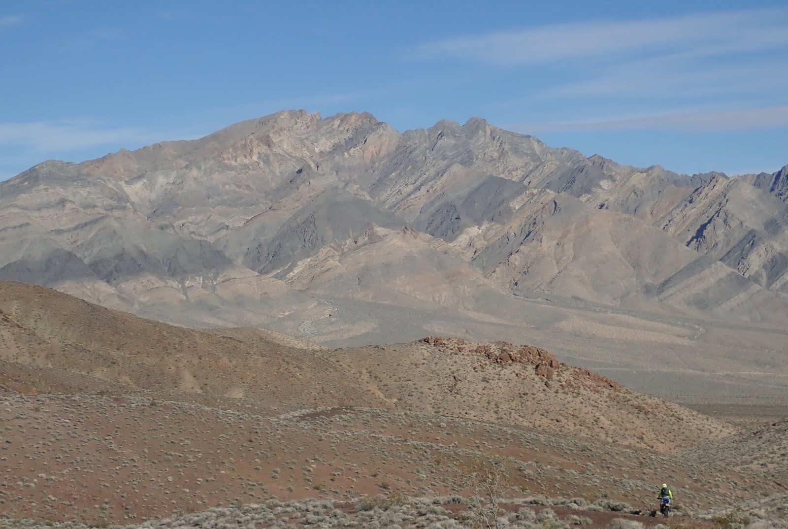
| Descending into Searles Valley (Trona) on day 1. The Slate Range is the small front range, Panamint Valley behind it, then the Panamint Range with snow-capped Telescope Peak, and Death Valley behind it. |
We stay at cabins Steve has found near Trona, but since we arrive early, we have time to ride up to some abandoned mines in the nearby mountains.
 |
| Late afternoon ride into the mountains, this formation had an almost unreal color in the late afternoon light, hard to capture on a photo. |
Day 2:
Very surprising, there is a real waterfall in Searles Valley. It is intermittent, of course, but this year runs unusually full. The winter of 1849/1850 was also unusually wet. But first, the Jayhawkers had to get down from the Slate Range and across the valley before there was any chance that they could find water.
 |
| "Those who bore farthest to the right, steering toward a pile of tremendous rocks, found a little stream of good water which flowed only a short distance and then sank into the sand.... Some took two canteens of water and hurried back to Mr. Isham who they found still alive but his mouth and throat so dry and parched, and his strength so small that he was unable to swallow a single drop, and while they waited he breathed his last. With their hands and feet they dug away the sand for a shallow grave. " William Lewis Manly (1894), Death Valley in '49, The Jayhawkers story |
After the waterfall, we got into some deeper sand where the riding gets a bit squirrely. Better for burying your companions than the rocks in the Slate Range the previous day(s):
"Both parties began the ascent of a black and barren range, containing no water, but in the bed of a ravine near the summit they found some damp sand and tried to dig with their hands to find some of the precious fluid. But no water came, and in the morning one of their number Mr. Fish died and was left unburied on the barren rocks. No doubt his bones could be found there to-day".
Sand is especially wobbly at slow speed and on a bicycle it is almost impossible to get enough speed to glide over it. More speed makes it easier and that's where an engine has a big advantage. John zoomed by and waved us on, trying to encourage us to speed up, but regardless of his gesturing, Albert or I didn't follow his prompt.
We enter the Slate Range on Stockwell Mine Road and descend on the eastern side into Panamint Valley through Fish Canyon (the '49ers ascended the range here).
 |
| Day 2, we just crossed the Slate Range and are descending into Panamint Valley, Telescope Peak ahead, Death Valley on the other side.
"Down the mountain they went, on the west side and instead of Los Angeles, which some of them expected to see, they saw only a salt lake in the midsts of a barren desert valley and their route lay directly across it. They traveled in several directions as they went across."
|
"These dry lake beds deceived them many times. They seemed as if containing plenty of water, and off the men would go to explore. They usually found the distance to them about three times as far as they at first supposed, and when they reached them they found no water, but a dry, shining bed, smooth as glass, but just clay, hard as a rock. Most of these dry lakes showed no outlet, nor any inlet for that matter, though at some period in the past they must have been full of water. Nothing grew in shape of vegetables or plants except a small, stunted, bitter brush". William Lewis Manly (1894), Death Valley in '49, The Jayhawkers story
We go around the salt marsh on the southern side and climb into the Panamint Range via Goler Canyon (also shows as Coyote Canyon Road on some maps). It is a jeep trail that goes into Death Valley National Park past Barker Ranch, where Charles Manson and his group where arrested (almost incidentally, the arrest was for vandalism, the sheriff and National Park Service only later realized that they captured a mass murderer and his followers).
 |
| Ascending the Panamint Range in Goler Canyon, look for all the brown round cacti growing on the rocks |
 |
| This is Death Valley proper, Badwater further to the left. |
At the bottom, we are very briefly on West Side Road, which is atrocious washboard. It wasn't always that bad, we did a family bike ride on West Side road in December 2011.
 |
| Family bike ride on West Side Road in December 2011 |
 |
| Titus Canyon, December 2011 |
Before whining too much about road condition, people had bigger concerns here in the past, long before there was any road in Death Valley:
"Five days they traveled, without finding water, and small supply they took along had been consumed. For lack of water they could not eat or sleep.... The range of mountains they had been aiming for still seemed far away and the possible show for reaching it seemed very poor indeed, and the prospect of any water hole between them and the mountains poorer yet. Hope was pretty near gone." William Lewis Manly (1894), Death Valley in '49, The Jayhawkers Story
Towards the end of the day, we cross the Amargosa River and go over a small mountain range between highway 127 and 178. The Amargosa River is almost 300 km long. It drains the high desert northwest of Las Vegas, then flows south into the Mojave Desert, and finally makes a sharp turn north again into Death Valley where it disappears in Badwater. Except, it is not a typical river because most of the water is underground. The Amargosa only flows above ground for short stretches in the Amargosa Canyon and near Beatty. I presume what we cross what normally is a dry wash (the real water is underground), and only has water because of recent rainstorms.
 |
| Near the end of day 2, we cross the Amargosa River, or at least a usually dry bed along its direction that right now has water because of recent storms. |
And soon the next big mountain range comes into view. The snow capped mountain is Charleston Peak, we will cross a bit further south through Red Rock Canyon. Las Vegas is in the valley behind it.
 |
| I think that is the Nopah Range in the front, Pahrump in the valley behind it, and Charleston Peak in the distance. |
 |
| Steve going down the single track towards Highway 178 |
Nick was probably the most competent motorcyclist after John and Steve, Albert may have been in the middle, but I generally felt like going a bit slower, so they had to wait. As I arrived at a more technical climb, John was waiting for me, the others had already tackled it, although I just saw how Albert took a hard fall and limped off near the top. Unfortunately, he also twisted his ankle and that limited his enjoyment of the last day. I had stopped at the bottom and talked to John about the line I saw to go up. He snorted "hah, that's a novice idea" and took a line I had not noticed before. I followed his line, which ended up being smoother than the one I would have taken.
Day 2 was the longest distance, about 150 miles and ended in Tecopa Springs. But the toughest section is from the geologist cabin to the center of death valley. Not because it is any technical challenge, but because it is a long rocky road that we ride at high speed. Albert called it "bone-jarring". I also felt pretty beaten up at the end of the day and enjoyed the hot tub in Tecopa Hot Springs more than I usually would.
 |
| Our rooms are just to the left, hot tub as well. There is a band stand and a band was playing from 6 on. |
We stayed at Tecopa Hot Springs, somewhat of a hippie place. They had live music, a slightly shaky band playing classic rock/pop tunes. I shared a room with Gil and our room had direct access to a hot tub. After dinner, I was getting cold again, my joints were still hurting, and the band was getting on my nerves. The drummer missed the beat when he did a roll on his toms and the mandolin player had an out-of-tune pair of A strings. Sitting in the hot tub with the water coming in cut those sounds enough to make the music even enjoyable.


 |
| Salt marsh around Tecopa Hot Springs watered by the Amargosa River |
Day 3:
A cold and gloomy day. We even got snow in the afternoon going over the pass into Red Rock Canyon. The first miles are near Kingston Peak and give a view into the valley with the Dumont Dunes, the town of Baker would be to the left/south and Death Valley to the right/north. With low hanging clouds, the photo fails to convey the impressive view.

Then we had a long sandy stretch to the appropriately named village Sandy Valley. I was happily moving at around 30mph in the deep sand. The handlebars wobble a bit, but it also isn't too fast to get nerve wrecking. I was definitely riding in my happy spot. The others went ahead a bit faster. A taco stand was parked in front of the Trails End General Store where a teenage girl took orders on her spiral bound notebook in English and Spanish and then conveyed them (in Spanish) to an older man next to her who assembled them. We now were in Nevada and she confirmed "Yes California is not far from here". She took her job seriously and would be a conscientious restaurant manager. According to Google Earth, California was about 1400 meters from the Taco stand.
John took his helmet off and barked out in frustration: "Roland, WHAT are you doing? I can't ride THAT SLOW in the sand!" Clearly exasperated, he pointed out that in his world the minimum speed limit to ride in deep sand is 40 mph. He was struggling how to explain such an obvious fact. "Have you ever waterskied?" No. "Well, you can't waterski slow either". I told him that 30mph was about as fast as I felt comfortable there. Any faster, and I wasn't confident I would see or recognize obstacles. But he would have none of that: "And if we go that slow, it is like being at Disneyland and doing teacups all the time and never get to ride the Matterhorn". Disney teacups were a recurrent theme, I got the distinct impression that neither John nor Steve like teacups.
 |
| I don't have insights about Disney's Matterhorn, but here is the real Matterhorn seen from a hike a few years ago. Not hiking on the Matterhorn itself, which is a very difficult climb. I believe this is the North Face, which wasn't climbed until the 1930s. We're teacupping it. |
The weather got gloomier and it started to snow a bit, so pictures that usually would be spectacular don't look like much. The very last stretch is the famed Red Rock Canyon. Mostly because it is a really pretty canyon that also sees lots of tourists from the Las Vegas side. Among offroad motorcyclists, it is apparently also known for the rocky uphill section that gets very congested during the annual LA-Barstow-Vegas ride the day after Thanksgiving. It is a fun section. Too bad it isn't very long, it is already over just when you get the hang of it, maybe just 1/4 mile. The rocky section is sufficiently challenging that I probably would not have tried it by myself on a solo trip and turned around, but it isn't that hard on a small motorcycle or on a bicycle (downhill only, would be pushing this uphill direction). Having seen it, I'd do it on my 225 on a solo trip, but would not do it by myself on a 400+ pound motorcycle.
 |
| Steve starting the rocky section of the Red Rock Canyon climb. |
 |
| I'm having a go at it |
 |
| And we're on top and it is snowing. Now 5 miles down to the pavement into Las Vegas |
 |
| The KTM in Red Rock Canyon, Nevada, shortly before we get to the pavement leading into Las Vegas. Coming down the mountain, the soil fairly suddenly turns red. |

 |
| On a sunny day, Red Rock Canyon must be spectacular, but it was very gloomy |
While it is still 25 miles to central Las Vegas, within minutes it feels like suburbia. New housing developments right and left, big intersections with long signal changes. Congestion isn't aggravating yet, but surely will be once those developments are finished. Soon it'll be as miserable as Los Angeles.
 |
| At the South Point Casino in Las Vegas |
We have dinner in the South Point Casino. It is the end of the trip for Nick and Albert who are staying in the hotel, the rest of us drive back to Palmdale in the van afterwards.
At dinner, I also get the full background on teacups. Steve supports visitors on the LA-Barstow-Vegas ride, which is such a well known event in the offroad motorcycle community that people come for pilgrimages. Motorcycle logistics are difficult (much more than joining a bicycle ride!) and it is also common to fail. Many participants underestimate distance, duration, or difficulty and don't finish. Steve tries to make sure that his customers end in Las Vegas and see all the highlights, especially Red Rock Canyon, along the way. That could mean encouraging them to ride the highway instead of the route to skip slow sections or even load them into a van to make up time. The Disney analogy is that the teacups are whoops and other stretches along the full route that take time and effort and some people skip those.
Driving back on I-15, we see helicopters covering the Mint 400 desert race still under way. Near Primm, some cars race along the freeway, going at a much faster speed. The motorcycles raced the day before, covering about 250 miles in under 5 hours (at least the top 3 did). So I guess for an ex desert racer like John, puttering along at 30 mph in an easy sand section this morning must be painful!


