About Me

My photo
Santa Monica, California, United States

Saturday, October 29, 2022

Bishop Pass, Dusy Basin, and Mt Agassiz


View from my camp in Dusy Basin, Palisades Range in the center, plus Isosceles and Columbine Peak on the right


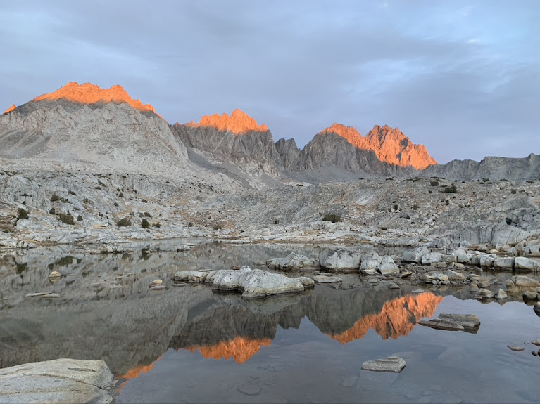
The sun is setting on the Palisades. From left to right: Mt. Agassiz, Mt. Winchell, Thunderbolt Peak

Last week in October, but the weather looked good and I went for one more high mountain trip. It is much colder than at the beginning of the month, nights are well below freezing. The aspen tell what a difference 3 weeks make:


First vs last week in October

Bishop Pass Trail is a very easy and pretty trail, over Bishop Pass into Dusy Basin and then a steep drop to connect with the John Muir trail. Also very popular and crowded during the main season. Mostly day hikers, but overnight permits (only required for overnight trips) are heavily oversubscribed and almost impossible to get in the summer. Similar to the Big Pine North Fork or Mt. Whitney areas.

Yet it turned out that in late October, permits for all days were available and on the day I went, mine was the only permit issued for that day (at least when I made the reservation, which was at 8am that morning - yes, no advance planning here).

I started hiking at 3pm and my car was the only one in the overnight parking lot (not entirely surprising, but then this lot is usually full with day hikers as all parking fills up - backpackers sometimes have to park 1 mile down the road because all other lots are day use only). Sunset was a 6pm and I stopped at Bishop Lake, about 7 km in. All the lakes along the trail are pretty and except for the first two miles, nobody else was out.


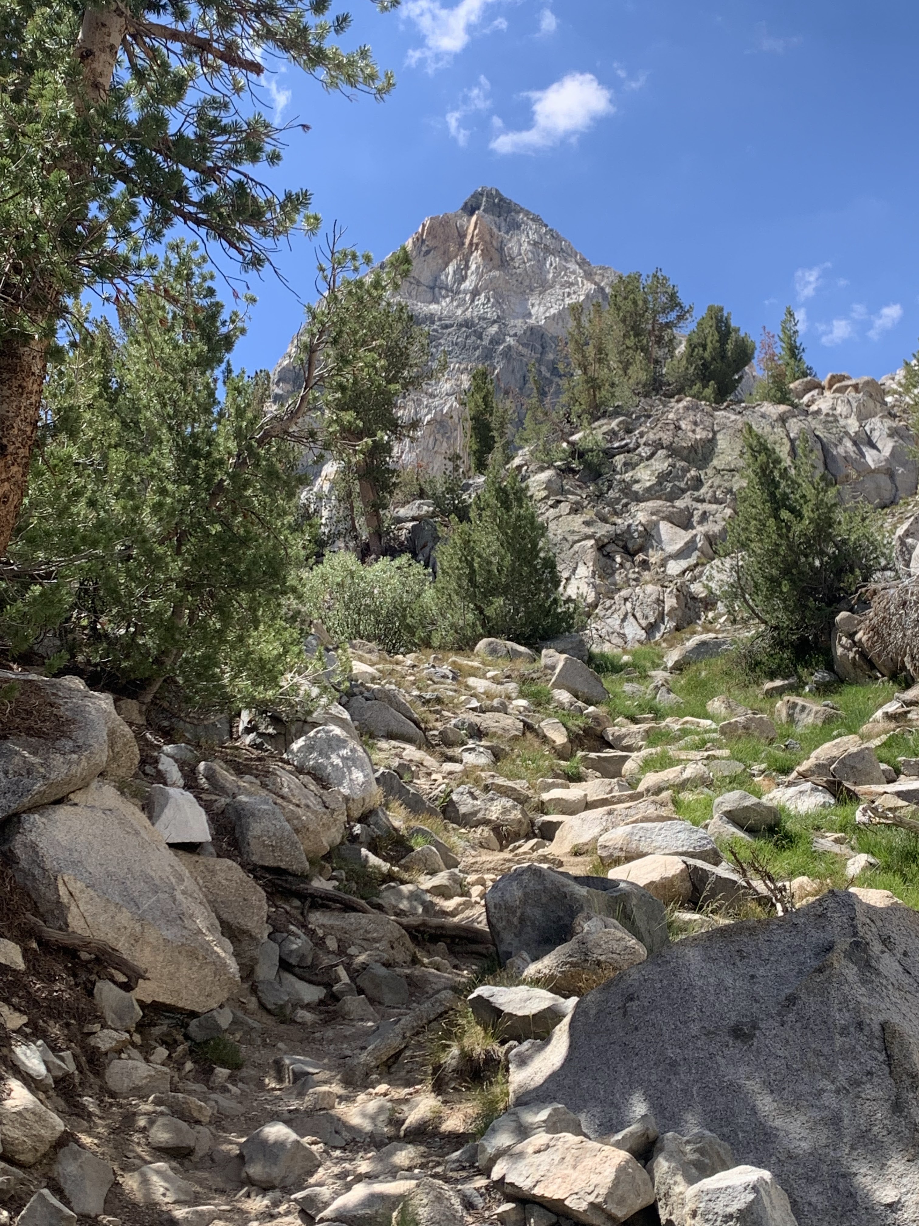
Bishop Pass Trail and Mt. Agassiz

Two mountains dominate the view early on the trail, Picture Puzzle and Mt Agassiz. Strangely, it turns out that Mt Agassiz muscled into about every picture I took.

And while Agassiz is an impressive mountain, it is not particularly outstanding in this neighborhood. There are more spectacular looking ones, starting with Picture Puzzle (of which I have no picture).


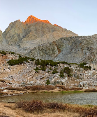
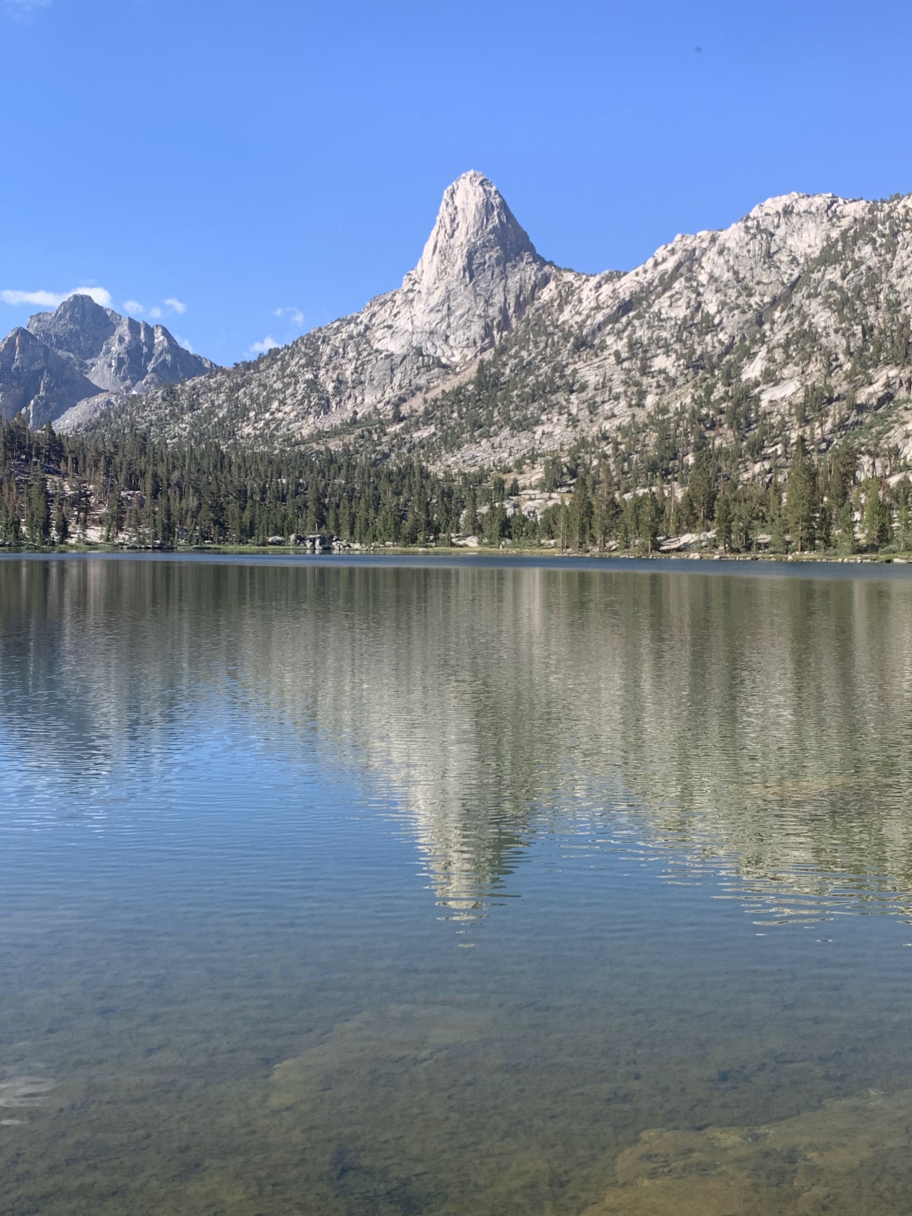
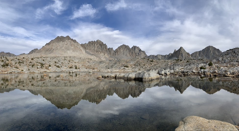
Bishop Lake and Mt. Agassiz
An hour or two later, the sun started to set and before it was gone, I took a picture of the red mountains. And back at home, I find out it is Agassiz again!

Mt. Agassiz is part of the Palisades range, a very steep and rugged group of 12 peaks. The range also has the biggest glacier in the Sierra Nevada, which feeds Big Pine Creek. In this company, Agassiz misses out on any awards, rank 5 in height with 4236m. The imperial measurement crowd adds insult to injury because using that scale it also is the first to miss out on being a "fourteener", despite being only 37m lower than Middle Palisades.

The night was cold, there is a reason why few people are out this time of year. All my water was frozen, but that was expected and I had filled up my pot. Only had to light my stove, no fight with getting ice water to flow.

Bishop Pass is one of the easiest passes and crosses into Sequoia and Kings Canyon National Park. To the east of the pass is Mt Agassiz, which is the last (as in "most northwest") of the Palisades. The aerial distance between Bishop Pass and the top of Mt. Agassiz is only about 1.2 km, but in the mountains it is not the distance that matters. Mt Agassiz is not a technical climb, just scrambling. I left my backback at the pass and made it to the top in about 2 hours and a bit less coming down.
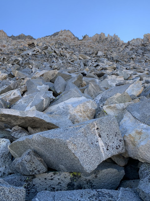
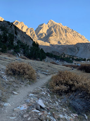


Starting the ascent


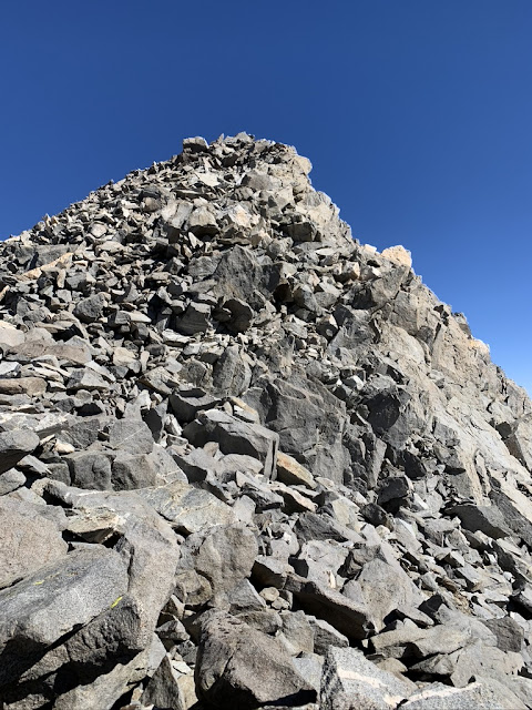
Last stretch, almost at the top


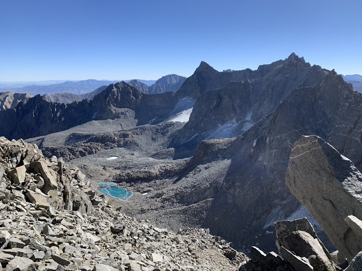
On top, looking down the east side of the Palisades with its two glaciers


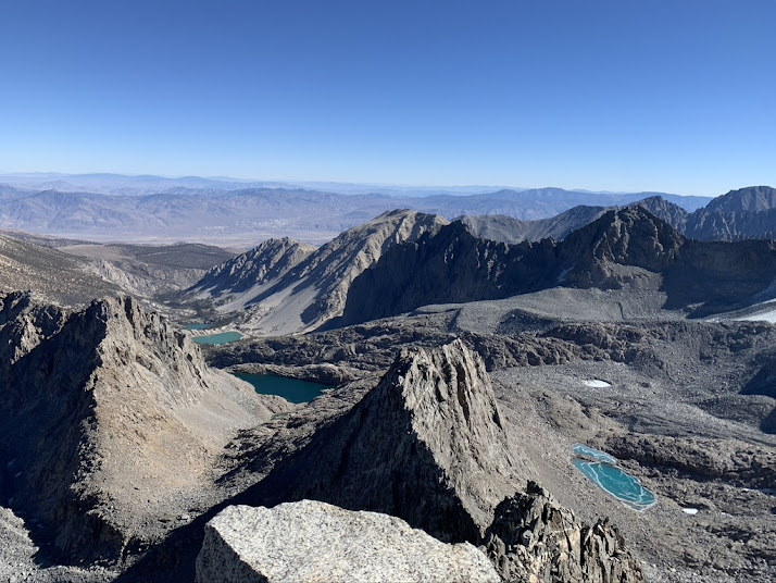
These are the lakes along the trail North Fork of Big Pine


Looking down at Bishop Pass. To the left of the Pass is Sequoia/Kings Canyon National Park

At the beginning of October, I went up the North Fork of Big Pine Creek. The two peaks I climbed, Cloudripper and Vagabond Peak, are very close, but considered to be in a different range. Here is how those areas hang together (or rather, how they do not hang together but are separated by tall mountains and valleys) - and that only works on a big screen. The previous hike is on the right, starting from Big Pine; this one is on the left, starting from Bishop/South Lake. In meters, not feet.


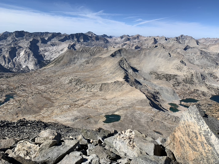
I continued into Dusy Basin, not far from Bishop Pass and not much lower. However, rather than the desolate moon landscape, it is much friendlier looking. It is somewhat swampy and that vegetation makes the difference. I made camp at one of the lakes. It was a very clear, but also very cold night. In the morning, the lake surface was frozen solid (there was very little ice in the evening). 

Dusy Basin. Isn't that Agassiz again on the left?

I hiked out in the morning, starting before sunrise. Very pretty and peaceful morning
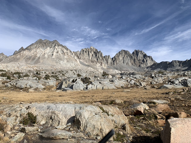
Long Lake

More Long Lake


Saturday, October 22, 2022

Fall Hikes Eastern Sierras

Two Eagle Peak and its morning reflection in Lake 7, Big Pine North Fork

September and October are the best time to go into the Sierras, days are still warm (but no longer hot), nights cool, and crowds and mosquitoes have thinned out (the latter completely after the first freezes). It is easy to get overnight permits, even for impacted areas like Mt. Whitney or Big Pine North Fork (which has a daily quota of 25). This time, I got a permit for Big Pine North Fork and left SM after teaching a statistics class in the morning. That was a 260 mile drive, but I was on the trail a little after 3 pm and by sunset made camp at a lake 1 (nobody else there).
Camp at Lake 1

The trails from the East start very similar: drive a few hours north through the desert, make a left turn in a small town, 20 minutes up a windy road, start hiking. First town is Lone Pine (Mt. Whitney), second town is Independence (Kearsarge Pass), third town is Big Pine (Big Pine North and South Forks), then Bishop (South Lake for Bishop Pass). Whitney is popular because it happens to be the highest mountain (making Lone Pine the biggest of the first three towns); Kearsarge connects with Kings Canyon National Park; Big Pine is pretty, but it is a small area because both North and South Fork trails dead-end. Big Pine has some of the best names: The North Fork trail goes into the Inconsolable Range and Cloudripper is the highest mountain among the Inconsolables.


Only 25 overnight permits are issued per day for the North Fork. However, it is also very popular with day visitors within the first miles from the trailhead. Dayhikers with dogs are a particular nuisance, dog poop on the trail (and "responsible" owners leaving it wrapped in plastic bags on the trail), loose dogs that "just want to play", annoying barkers. Both on the way in and the way out. There is a pretty area with Aspens early on and they were in fall colors. Unfortunately, they are also heavily graffitied, suffering from the popularity. Fortunately, 2 hours of hiking gets you beyond that.

Cloudripper (on the right) from a distance, it is the highest peak in the Inconsolable Range


There are 7 numbered lakes (1-7) and a few other lakes. The main area is easy trails with gentle gradients up to where the trail splits into a branch going to Palisades Glacier and a branch to Lakes 4/5 (it is still a lot of climbing, so easy conditional on 1000m gain). Few day visitors (which is the majority) beyond Lakes 4/5 and I didn't see anybody at all for 1 1/2 days once past Lake 5.

The trail seems to end at a campsite at Lake 6, after that comes a swampy meadow up to Lake 7. I stopped for lunch at Lake 7, set up my tent, and left the luggage there.

Many lakes, more than 7


After Lake 7, it goes up steeply in almost every direction, it sits at the foot of the Inconsolable Range. The tallest mountain in that range is Cloudripper at 4122 m (so not quite a 14er) and supposedly not a technical climb. I had not looked for descriptions beforehand, so I had to search for routes. The initial route I took was the wrong one - or at least a route that was becoming much more technical than what I would do. From the bottom, it is hard to tell what is and is not workable, I ruled out a chute to the far right which looked too steep and all loose scree (AFTER a big chunk of talus hopping). But that was the way to go after all.


Now which way? (Turns out none of those, it would be further to the right, but I only figured that out later)


Made it to the ridge, now just straight ahead along the ridge


View from Cloudripper southeast to the Palisades and Palisades Glacier


Looking the other direction from Cloudripper towards Bishop Pass/Dusy Basin

Turns out that there is another tall peak very close to Cloudripper, in fact, the second highest in the Inconsolable Range and also over 4000m: Vagabond Peak. It is not particularly difficult either (I hiked in running shoes), but a bit more scrambling than Cloudripper at the top. Coming down from Vagabond Peak, I heard some voices in the distance, presumably a group was either climbing or descending Cloudripper, but I didn't see anybody. In fact, I didn't see anybody all day.


I was back at my tent by 5.30, so had a little bit of daylight left. I walked out the next morning.

back at my campsite at lake 7


Friday, October 21, 2022

Another try at Mt Whitney in the Fall


View of Sequoia National Park from the East - yes, this is all National Park as far as you can see

Fall is usually a good time to go in the mountains. It is easy to get permits on short notice that usually require participation in a lottery - like Mt. Whitney. Crowds and mosquitoes have thinned out, days are no longer hot, but nights are not yet too cold. Usually.... Last year around this time, I had one fail and that was at Whitney. It started and ended beautifully, but the time in between was rough after an unexpected storm destroyed my tent.  Maybe the most miserable night I had on any trip.  


Whitney is the slightly rounder peak

So now there was a reason to make it to the top of Whitney. Until last year, I never tried because it has little appeal to me: The Mt. Whitney area itself is congested because it is the highest mountain in the contiguous 48 states at 4400m/14500 feet. Entering the Whitney area requires permits even for day hikes. Those are so oversubscribed that they are awarded through a lottery at the beginning of the year. There is nothing difficult about it and more than 100 years ago (and long before trails received maintenance), John Muir wrote that

"...in summer no extraordinary danger need be encountered Almost any one able to cross a cobblestoned street in a crowd may climb Mt. Whitney."
Muir, John. The Complete Works of John Muir: Travel Memoirs, Wilderness Essays, Environmental Studies & Letters (p. 1801). Madison & Adams Press.

 No kidding, this is the trail after Mirror Lake, well above 3000m (or 10000 feet for those that count with their extremities) capturing a moment without people on it. 

And the trail surely was rougher during John Muir's days

So Whitney may not exactly be my thing, but that freak snow storm last year that destroyed my tent put Whitney high on my agenda. Not high enough to plan in advance, but then this isn't necessary in the fall. I checked recreation.gov one morning, saw an overnight permit for that day, packed up and was on the trail before 4pm. 


Permits are by a lottery with low chances - or easy to get in October as long as you are flexible (same day or next!)  


Going up the main Whitney trail, now almost at the treeline. 

It was lovely afternoon, not too hot (cloudy and a bit drizzly), but forecast was above freezing (well, last year unexpectedly turned out to be much different in the end).  

Thor Peak (3750m) looms over much of the hike and it is a more impressive mountain than the picture shows

my tent at Consultation Lake
Dawdling too much taking pictures, so time to speed up because I was about to run out of daylight before getting to Consultation Lake (ok, I DID run out of daylight). But now I know a hiking route (no scrambling required) to descend to Consultation Lake. No light needed for that. I was the only camper at Consultation Lake, like last year. Few people seem to make the detour to the lake, maybe because there is an official camping location, Trail Camp, just a bit further on the trail. But Consultation Lake is SO much nicer!

Night was a bit restless, at least initially, but that is not unexpected at 3600m without acclimatization. Tent wasn't needed this time and I actually stayed outside until the moon became too noisy (it was close to full moon). I didn't wake up until after 7.30 and by then the temperature was already pleasant. Very different from last year. 

Trail Camp is just up the road from Consultation Lake, 15-20 mins, but what a different scene. Dozens of people crowded along the trail around a muddy pond. I go into the mountains to avoid this, but some seem to seek it out. The infamous 99 switchback section starts right after Trail Camp. Halfway up I took a picture to show you the difference between Consultation Lake and Trail Camp. On the right, Consultation Lake, I was the only person there. See the small greenish pond on the left? That is Trail Camp, dozens of people and tents every day. 


Consultation Lake on the right. Small greenish pond on the left is the crowded Trail Camp

99 switchbacks is a fairly tedious slog. Takes about 1 1/2 hours, 500-600 m or so elevation gain. Nothing difficult or hard, just tedious. A very well developed trail. 

But at the top comes Trail Crest and the connector with the John Muir Trail and that is an impressive view of Sequoia and Kings Canyon National Parks as far as one can see. 

Looking East from Trailcrest
Trail Crest


It is pretty rocky around Trail Crest, but what truly astonished me is the effort that went into trail building. Big rocks on a steep slope, yet rearranged to make almost a staircase:


Another hour or so from there to the top. Yes, highest mountain I've been on. Not the most rewarding one, though. And too crowded. 


Saturday, October 1, 2022

The Enduring Charm of Obsolete Instruments


Aluminum resonator (“resophonic”) instruments were an early 1900s attempt to mechanically amplify string instruments. Their time in the sun was rather brief – mainly the late 1920 – because as soon as there was a decent sounding and reasonably affordable resophonic instrument, the technology was outdated and completely superseded by electric amplification. There is a small niche for modern versions and I just added an 8-string resonator slide guitar to provide some company for my (modern) National resonator mandolin.


The best known effort was by Los Angeles instrument repairman/inventor John Dopyera who built a “resophonic” (or “ampliphonic”) guitar for the musician George Beauchamp. Together they founded the National Company and the instruments quickly became popular, especially for the then hugely popular Hawaiian slide guitar style. And that style urgently needed something punchier than regular guitars played with a steel bar. Their collaboration did not last long and Dopyera left the National Company in 1929 to start the competing “Dobro Manufacturing Company” with his brothers. Dobro was a contraction of “Dopyera brothers”, but conveniently also meant “good” in their native Slovak language, an idea reflected in the company motto “Dobro means good in any language.” National and Dobro did not compete for long and merged into the National-Dobro Corporation in 1934. By then the decline of resophonic instruments was already under way because electric amplification rendered mechanical amplification instantly obsolete. At that time, the only reason for resophonic instruments was added volume and that advantage was gone. For the next decades, the electric steel guitar ruled (before it fell out of fashion itself): The Forgotten Steel Guitar

Beauchamp himself had started a new company with Adolph Rickenbacher in 1931 that sold electric steel guitar. National-Dobro moved from Los Angeles to Chicago and started building electric instruments. After 1941, National did not produce any original resonators and those designs were only revived by National Reso-Phonic Guitars, a San Luis Obispo company founded in 1989. Production of resophonic instruments under the Dobro label also ended in the 1940s, but Dobros had an earlier revival caused by bluegrass.


National “biscuit” resonator on top, Dobro “spider” resonator at the bottom

The main difference between National and Dobro instruments is how the aluminum resonator cone amplifies the string vibrations through the bridge. National instruments have a resonator in a mountain shape – it is lowest at the edge with a peak in the center. A wooden disc (“biscuit”) is glued to the peak and the bridge sits on the biscuit. Dobros turn the resonator upside down, it is a valley (lowest in the center). On top is a “spider”, a cast metal framework, and a threaded bolt connects the center of the bridge through the spider to the bottom center of the cone. While necessitated by patent restrictions, both designs work well. I now have one of each.

Resonator instruments have their own timbre. Neither like a typical acoustic (wood only) instrument nor like an electric. A bit metallic, sometimes rather rough, but that is exactly what blues players like, like Bukka White in this video. My mandolin can be very loud, so the mechanical amplification does work, but played gently has an attractive tone on its own.

Dopyera was not the first builder of metal resophonic instruments. That credit may belong to Augustus Stroh, who got a UK patent for a violin in 1900 on “Improvements in Violins and other Stringed Instruments”. His patent described a flat metal diaphragm to mechanically amplify the sound and a year later extended the concept to a conical resonator with corrugations at its edge, allowing a more ‘rigid’ diaphragm. He never registered his inventions in the USA, otherwise Dopyera and Beauchamp may not have been able to get their Nati0nal design patented.

The Stroh violin was an expensive instrument, roughly 6 times the price of a decent factory violin. Combined with its rather shrill tone, lacking the more appealing characteristics of a violin, it never received widespread acceptance, not even briefly. It remained a rarity, although it has been the trademark of the Irish fiddler Julia Clifford (but I think most of her recordings were on a regular fiddle). Surely more appropriate for Sliabh Lucra polkas in a noisy pub than for a Beethoven string quartet in a recital hall


Julia Clifford and her Stroh fiddle

Monday, July 18, 2022

Kings Canyon National Park: 60 Lake, Gardiner, Rae Lakes Basin


Sixty Lake Basin

Four days in the High Sierra

The Eastern Sierras are within easy reach from LA, about 4 hours to trailheads and offer an amazing alpine scenery that never disappoints. No matter how much further you want to travel, it won't get any better. The downside is that trails can be congested, especially the (deservedly famous) John Muir Trail or Rae Lakes loop. However, combined with some cross-country (no trail) hiking I had many hours without encountering anybody.

I left Santa Monica at noon and was on the Kearsarge Pass trail a little after 4 pm. It was a thundery afternoon and got a bit drizzled on. Actually perfect as the clouds and drizzle kept the temperature down. Otherwise, this could be a really hot climb. I need about 3 hours to get to Kearsarge Pass, it always is a very hard ascent, even if the temperature is pleasant. On paper, Kearsarge Pass doesn't look as hard as it feels, about 7.5 km and 800 m, but it wrecks me everytime. Maybe because of the altitude coming from sea level? Kearsarge Pass is 3600 m high after all. I also had a heavy backpack this time as I packed for 5 days. Whatever it is, Kearsarge Lakes, just about 2 km downhill from the pass, make a good first destination. Last year, Kathy and I just did that part, more detail (and John Muir quotes) here: https://rolandsturm.blogspot.com/2021/06/eastern-sierras.html

going up Kearsarge Pass trail on a cloudy afternoon


This root sculpture is still a living tree! University Peak on the left 


There is no easy way to get past the mountain barrier on the eastern end, only strenuous ones. Kearsarge Pass Trail is easier and shorter than the others, Baxter, Sawmill, or Taboose, are twice the effort because they start much lower. Sawmill is 20km long with 2000m of gain. Kearsarge is 7.5 km and 800 m of gain. It comes at the price of extreme popularity, including people with their dogs, which is most annoying during the first half up to Flower lake. Then it thins out a bit and the other side of the pass is Kings Canyon National Park where pets aren't allowed.


Sunset at the 3rd Kearsarge Lake


Sunrise at the 3rd Kearsarge Lake

The next morning, I connected with the John Muir Trail (JMT) going north towards Rae Lakes and by noon was over Glenn Pass, also around 3600m, but only 400m of gain. It still is a hard climb with a big pack.


Bullfrog lake on the left


The John Muir Trail and Rae Lakes loop are well known and extremely popular. Too many people all looking for solitude and remoteness! If you look at maps, the Rae Lakes loop goes around the Gardiner Basin and 60 Lake Basin, mostly along creeks/rivers. On the west, it is the South Fork of the Kings river, on the north Woods Creek, on the south Bubbs Creek, on the east Rae Lakes. In the middle are two basins with lots of lakes, but there are no maintained trails there. The two big peaks separating the Gardiner and 60 Lakes basins are Mt Clarence King and Mt Gardiner. They can be connected via 60 Lakes Col. So that's where I headed this time.


Going north on the JMT over Glenn Pass, I turned off the trail about halfway down (200 m down from the top, to Rae Lakes would be another 200m of descent).


View from Glenn Pass, Rae Lakes are on the right further down and you can see the valley where the JMT runs. The 4 or 5 lakes on the left are off the trail, up from there and over the ridge on the left outside the picture gets into 60 Lakes. 


Off the beaten path. From this lake, the long one one on the left in the previous picture, I am trying to find a way over Rae Col to 60 lakes.


Wasn't too difficult to find a way to the top, this is going down the other side. A bit steeper, but not too hard either. 


Steep scree slope and then some talus rock hopping to lake 3353


As soon as I turned off the trail, there were no more people. I saw a Sierra Nevada bighorn sheep, though. Only a tiny fraction of people like to travel cross-country and then they disperse very quickly when there are no trails. In any event, I didn't encounter anybody until I would rejoin the JMT. Lots of pretty lakes here and now truly remote, making it much more attractive to me than Rae Lakes just one or two ranges east from here.

Halfway down to lake 3353

Most lakes or peaks don't have names and are labeled with the elevation on USGS topo maps. The topo maps use meters, but older descriptions may be in feet from older topo maps. In any event, lake 3353 is the first one descending via Rae Col into 60 Lake Basin, lake 3304 is towards 60 Lake Col that links the two basins and the first lake on in Gardiner Basin would be 3477 (very rocky area and hard to get around) before dropping to lake 3214. Nowhere as poetic Bullfrog or Arrowhead along the established trails (they have labels, too: Bullfrog is 3234, Arrowhead 3137, middle Rae Lake 3212), but more informative what it takes to get there.


Mosquitoes were mixed. Mid-July is about peak season for them and there were some bad spots, but also many where they were completely absent. Two nights I didn't have any problems, even sitting by the lake during sunset. One night I had to get into the tent by 5pm. During the day, sometimes I had to change plans when to take a break, but always found a mosquito free area. It is possible to leave Gardiner via King Col, it is mentioned in RJ Sector's book "The High Sierras" as a class 2, but then found reports that this was sketchy. The north side supposedly has a snow cornice, an overhanging mass of hardened snow at the edge of a precipice, year round. I was alone nor prepared for anything beyond hiking. Certainly wouldn't want to get close to a cornice. Instead, I took the easy route out from 60 Lakes via Basin Notch.

Mt. Cotter and Mt. Clarence King
It became bright again after midnight with a full moon, with its reflection in a lake

Connecting back with the JMT via Basin Notch at Arrowhead Lake, nothing too difficult here, although I had to backtrack once

Rae Lakes

Fin Dome separates Rae Lakes and Sixty Lakes, a landmark from both sides (this picture has Rae Lakes in the foreground). 


Painted Lady is next to the first Rae Lake. Going south, this is where the climb to Glenn Pass starts again

Mt. Rixford (3928 on USGS topo maps)


Still struggling with Glenn Pass


That afternoon became very wet and it rained for several hours, repeated thunderstorms. Unlike my bike trip last month where I got very chilled with a 20 min storm, this time I didn't even add another layer. It was not exactly comfortable, but not particularly unpleasant although I was wet for 3-4 hours. By 5, the sun came out again and it became almost too warm. I returned to Kearsarge Lakes for the night and the next morning hiked out. 


Kearsarge Lakes and Pinnacles