About Me

My photo
Santa Monica, California, United States

Monday, July 18, 2022

Kings Canyon National Park: 60 Lake, Gardiner, Rae Lakes Basin


Sixty Lake Basin

Four days in the High Sierra

The Eastern Sierras are within easy reach from LA, about 4 hours to trailheads and offer an amazing alpine scenery that never disappoints. No matter how much further you want to travel, it won't get any better. The downside is that trails can be congested, especially the (deservedly famous) John Muir Trail or Rae Lakes loop. However, combined with some cross-country (no trail) hiking I had many hours without encountering anybody.

I left Santa Monica at noon and was on the Kearsarge Pass trail a little after 4 pm. It was a thundery afternoon and got a bit drizzled on. Actually perfect as the clouds and drizzle kept the temperature down. Otherwise, this could be a really hot climb. I need about 3 hours to get to Kearsarge Pass, it always is a very hard ascent, even if the temperature is pleasant. On paper, Kearsarge Pass doesn't look as hard as it feels, about 7.5 km and 800 m, but it wrecks me everytime. Maybe because of the altitude coming from sea level? Kearsarge Pass is 3600 m high after all. I also had a heavy backpack this time as I packed for 5 days. Whatever it is, Kearsarge Lakes, just about 2 km downhill from the pass, make a good first destination. Last year, Kathy and I just did that part, more detail (and John Muir quotes) here: https://rolandsturm.blogspot.com/2021/06/eastern-sierras.html

going up Kearsarge Pass trail on a cloudy afternoon


This root sculpture is still a living tree! University Peak on the left 


There is no easy way to get past the mountain barrier on the eastern end, only strenuous ones. Kearsarge Pass Trail is easier and shorter than the others, Baxter, Sawmill, or Taboose, are twice the effort because they start much lower. Sawmill is 20km long with 2000m of gain. Kearsarge is 7.5 km and 800 m of gain. It comes at the price of extreme popularity, including people with their dogs, which is most annoying during the first half up to Flower lake. Then it thins out a bit and the other side of the pass is Kings Canyon National Park where pets aren't allowed.


Sunset at the 3rd Kearsarge Lake


Sunrise at the 3rd Kearsarge Lake

The next morning, I connected with the John Muir Trail (JMT) going north towards Rae Lakes and by noon was over Glenn Pass, also around 3600m, but only 400m of gain. It still is a hard climb with a big pack.


Bullfrog lake on the left


The John Muir Trail and Rae Lakes loop are well known and extremely popular. Too many people all looking for solitude and remoteness! If you look at maps, the Rae Lakes loop goes around the Gardiner Basin and 60 Lake Basin, mostly along creeks/rivers. On the west, it is the South Fork of the Kings river, on the north Woods Creek, on the south Bubbs Creek, on the east Rae Lakes. In the middle are two basins with lots of lakes, but there are no maintained trails there. The two big peaks separating the Gardiner and 60 Lakes basins are Mt Clarence King and Mt Gardiner. They can be connected via 60 Lakes Col. So that's where I headed this time.


Going north on the JMT over Glenn Pass, I turned off the trail about halfway down (200 m down from the top, to Rae Lakes would be another 200m of descent).


View from Glenn Pass, Rae Lakes are on the right further down and you can see the valley where the JMT runs. The 4 or 5 lakes on the left are off the trail, up from there and over the ridge on the left outside the picture gets into 60 Lakes. 


Off the beaten path. From this lake, the long one one on the left in the previous picture, I am trying to find a way over Rae Col to 60 lakes.


Wasn't too difficult to find a way to the top, this is going down the other side. A bit steeper, but not too hard either. 


Steep scree slope and then some talus rock hopping to lake 3353


As soon as I turned off the trail, there were no more people. I saw a Sierra Nevada bighorn sheep, though. Only a tiny fraction of people like to travel cross-country and then they disperse very quickly when there are no trails. In any event, I didn't encounter anybody until I would rejoin the JMT. Lots of pretty lakes here and now truly remote, making it much more attractive to me than Rae Lakes just one or two ranges east from here.

Halfway down to lake 3353

Most lakes or peaks don't have names and are labeled with the elevation on USGS topo maps. The topo maps use meters, but older descriptions may be in feet from older topo maps. In any event, lake 3353 is the first one descending via Rae Col into 60 Lake Basin, lake 3304 is towards 60 Lake Col that links the two basins and the first lake on in Gardiner Basin would be 3477 (very rocky area and hard to get around) before dropping to lake 3214. Nowhere as poetic Bullfrog or Arrowhead along the established trails (they have labels, too: Bullfrog is 3234, Arrowhead 3137, middle Rae Lake 3212), but more informative what it takes to get there.


Mosquitoes were mixed. Mid-July is about peak season for them and there were some bad spots, but also many where they were completely absent. Two nights I didn't have any problems, even sitting by the lake during sunset. One night I had to get into the tent by 5pm. During the day, sometimes I had to change plans when to take a break, but always found a mosquito free area. It is possible to leave Gardiner via King Col, it is mentioned in RJ Sector's book "The High Sierras" as a class 2, but then found reports that this was sketchy. The north side supposedly has a snow cornice, an overhanging mass of hardened snow at the edge of a precipice, year round. I was alone nor prepared for anything beyond hiking. Certainly wouldn't want to get close to a cornice. Instead, I took the easy route out from 60 Lakes via Basin Notch.

Mt. Cotter and Mt. Clarence King
It became bright again after midnight with a full moon, with its reflection in a lake

Connecting back with the JMT via Basin Notch at Arrowhead Lake, nothing too difficult here, although I had to backtrack once

Rae Lakes

Fin Dome separates Rae Lakes and Sixty Lakes, a landmark from both sides (this picture has Rae Lakes in the foreground). 


Painted Lady is next to the first Rae Lake. Going south, this is where the climb to Glenn Pass starts again

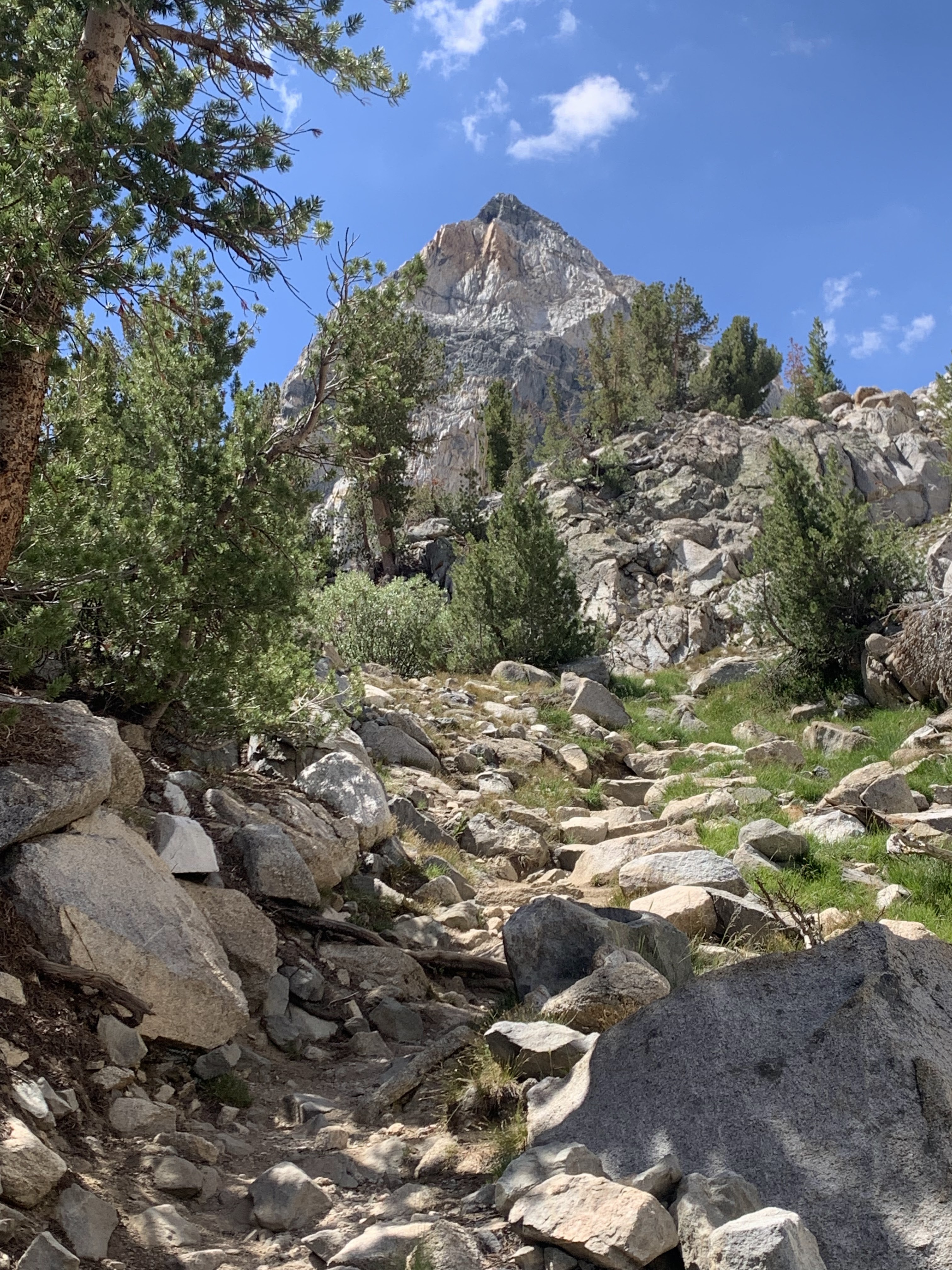
Mt. Rixford (3928 on USGS topo maps)


Still struggling with Glenn Pass


That afternoon became very wet and it rained for several hours, repeated thunderstorms. Unlike my bike trip last month where I got very chilled with a 20 min storm, this time I didn't even add another layer. It was not exactly comfortable, but not particularly unpleasant although I was wet for 3-4 hours. By 5, the sun came out again and it became almost too warm. I returned to Kearsarge Lakes for the night and the next morning hiked out. 


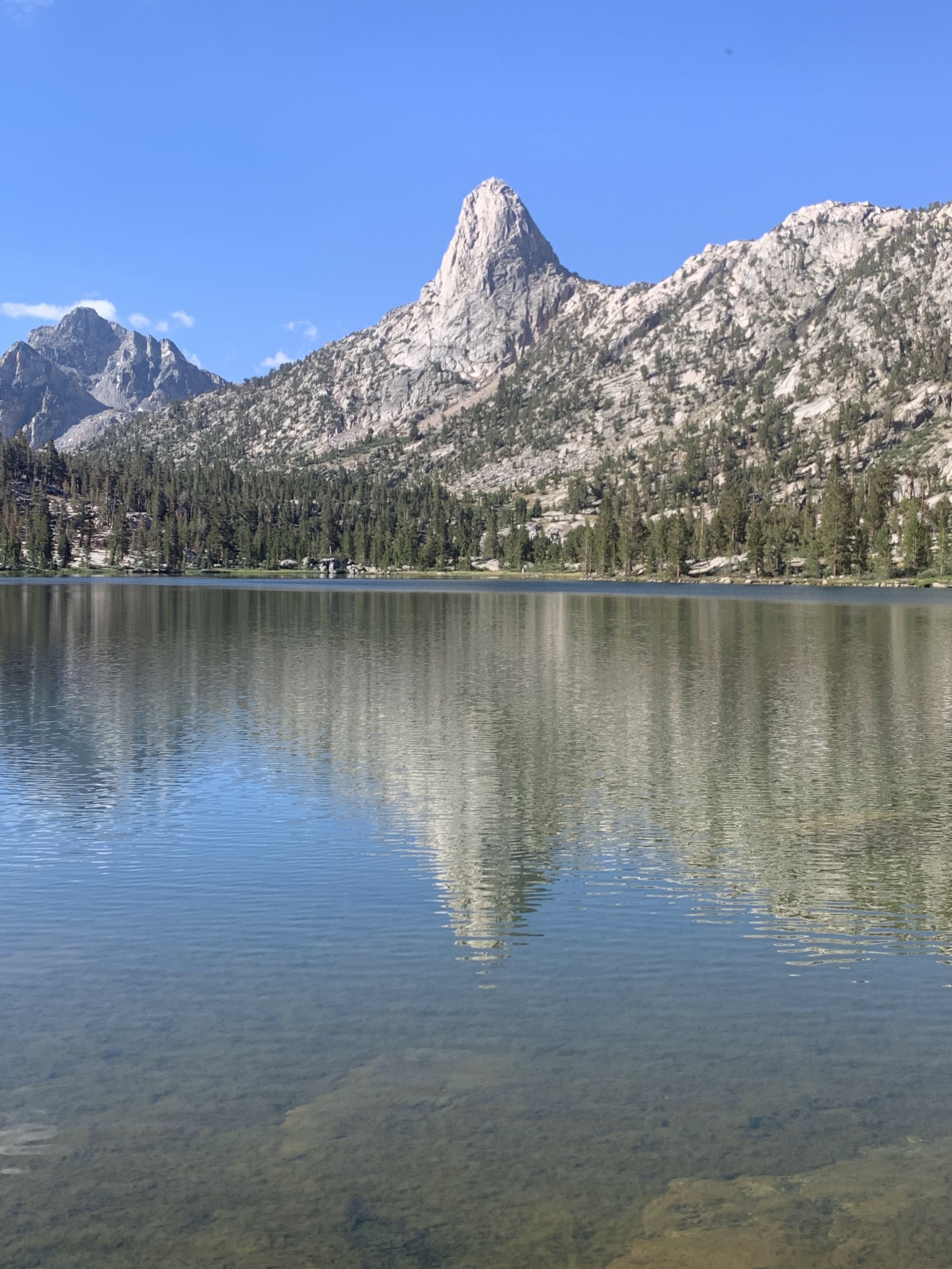
Kearsarge Lakes and Pinnacles


First 2022 Bikepacking Trip: Lake Tahoe Bones to Blue


First multi-day bikepacking trip in 2 years! That was a long pause, the longest in more than a decade, and only partly due to covid or repeated wildfires. Even in 2022, I was sluggish and had not planned anything yet. Then saw that the Bones to Blue bikepacking route was having a group start in June and that was an easy one to hop on. The route suffered from wildfires and smoke both in 2020 and 2021.  

5:55 am - biggest group ever starting together on this route in downtown Truckee

The Bones to Blue bikepacking route consists of separate 2 loops that start and end in Truckee for a total of about 400km/250 miles: A smaller loop above Truckee (Bones) and then a bigger loop around Lake Tahoe (Blue). Forest Baker (to the right of the stop sign in the picture) has developed the route and reconnoiters it regularly - even checking on possible problem spots (snow) right before the group start. He knows what makes for a good route and the area offers many possibilities. Mostly single track, only minimal amount of pavement that cannot be avoided (even that is scenic and not too aggravating with traffic). No junk miles make it one of the best multi-day bikepacking routes. The site for the route with gpx files is here: http://bonestoblue.com/


When experienced bikepackers put together a route they like to ride, it is going to be a good route! 

It is a much more challenging route physically than it looks on paper because of elevation gain, altitude, and single track. Even Forest's "Forlorn 4 day ride" is a hard touring pace with 35-40 (or more!) hours of moving time. The fastest riders can do the whole route in under 48 hours total and there were a bunch of them this year. Jeff Kerkove finished in 37 hours and set a new course record. 

The inaugural event for the Bones to Blue route was in 2017, although I missed the initial event because I went on the TransCanada Trail aka "Great Trail" that year. The TransCanada Trail received much media attention then because it was officially completed after being 25 years in the works, celebrated by even getting the new name "Great Trail". Reality was far from the hype - but you only find that out by doing it: Biking the TransCanada Trail. In contrast, Bones to Blue is a fantastic route put together by somebody who understands mountain biking.  

In 2018, I rode the Bones loop and about half of the Blue loop two weeks after the group event and in 2019 I did the Blue loop minus two sections. https://rolandsturm.blogspot.com/2018/08/  But I had not done the whole route yet. It also changes over time, though slightly. Around Prosser Hill, previous incarnations of the route went  into an area also used by motorized vehicles, which made for a sandy and tedious start. But this year's route has improved on it and has excellent trails at the beginning.


Less than 15 minutes on the Bones Loop and I already take a photo stop


And I already missed a turn in the first hour and am going up the wrong ridge on the wrong side of the river. Had to backtrack later, but it was still enjoyable early in the morning.  

An hour later, back on the right trail!


The day before the start, there is a pre-meeting at Pizza on the Hill. A nice opportunity to meet other similarly-minded riders (everybody rides their own pace, so during the day you rarely see/talk to anybody). And with Covid - and also the huge changes/growth the bikepacking community experienced over the last decade - nice to catch up. 

Talking to Forest and Alissa


I've known Forest for more than a decade, we met on many similar events. Alissa Bell is a newer participant to bikepacking, but with plenty of backpacking experience and huge endurance. She has an excellent website/blog that I had seen before and recommended, although only made that connection later.  https://exploringwild.com/  While most of us probably try to start well recovered because this loop is going to be a major effort, Alissa had been out for 5 days hiking in the Desolation Wilderness, description on her website.


Looks like I've become the old guy in those events. Blake Bockius wasn't there and
that probably left me as the only one over 60.


The "Bones" in the smaller one day loop refers to the fate of the Donner party in 1846/47. The Donner Party began as just another nameless pioneer trek to California, but the Great American Dream turned into a nightmare. Surely they would have preferred not having a lake or pass named after them. Based on one count of the group (which includes the Miwok guides Luis and Salvador), 42 out of 90 died and cannibalism saved some of the survivors. The Bones loop goes north of Truckee, past Alder Creek where the 2 Donner families spent the winter in of 1846/47. George and Jacob Donner had fallen behind the rest of the group after breaking an axle on a wagon (neither survived). Most other families were a few miles ahead and wintered at Donner Lake. 


Not this time, years ago.
The Hole in the Leg section
 on the Hole in the Ground trail.


 The infamous Hole in the Ground trail. It has left holes in many people over the years. Indeed, two scars on my right leg are from it. Yet Forest pre-rode it the week before just to make sure it wasn't going to be too brutal (because of late snow and fallen trees). 


Hail before it started pouring
There was a 20% chance of isolated thunderstorms. Unfortunately, for me it was a 100% and even was pelted with hail right when I was on a fully exposed section. People faster than me (like Forest, Julie) were already sheltered, people behind me didn't get rained on. But the isolated thunderstorm did find me and I was getting quite chilled. 


The last section is over Donner Pass and through the original Donner Pass train tunnels, riding over the top of the China Wall, which exerted a high toll among the Chinese laborers who did the dangerous and arduous work to connect the transcontinental railroad through the Sierras. Actually a tedious gravel section, although the novelty factor doing it the first time will compensate and it is slightly downhill. It wasn't my first time, though, so no compensating novelty. 
 

In the tunnel!

I had signed up for the "Forlorn" route where Forest even reserved camping sites. So a much more social ride than I usually do and his wife Annie and their kids joined us that evening with supplies. 


The second "Blue Loop" goes around Lake Tahoe, using the bike-legal sections of the Tahoe Rim Trail wherever possible. There is a lot of climbing, but it is very rideable. There are several Flume trails (distinguished by some second part in their name). Unfortunately, it was middle of day on a weekend, so those trails were crowded.
Just such a good trail going around Lake Tahoe!

The first Flume trail, coming after the climb out of Incline Village, is the prototype of smooth flowing single track (Incline-Flume trail). I trust there are hardcore riders who will find this just "too easy and boring", but it would be my favorite trail, just avoid it middle of the day on a weekend. 


For night 2, Forest had reserved a cabin at Spooner Lake. At this time of year, a swampy lake area could be mosquito hell, but it wasn't.  None at all, I even sat by the lake at sunset. This is likely to change in July, I suspect we just were out a little early. On the Bones route, there were already several patches with aggressive mosquitoes. Another bonus for June, it might be the ideal time: Long daylight, low probability of wildfires, warm but not too hot, before the mosquito peak. Only risk is lingering snow, but there was virtually none left. 

Spooner Lake at Sunset
Didn't use the rainfly on this trip. Tent at Spooner near the cabin

At the Spooner Cabin, Walter Dunckel, Julie Kanagy, Jake Inserra, and me

The next day was going to be the longest one among 4 days where none was short. I think I was on the trail by 5 am. While I was the first to leave Spooner in the morning, it didn't take long for Forest and Julie Kanagy to catch up with me and we rode the section to Kingsbury together. That was a more technical section and it was fun to ride with them - and also faster than I would have gone by myself. Helps following a rider. I tried to take some pictures, but especially Julie is just too fast and was out of sight before I could get good pictures at the interesting sections.

Only got Julie in the picture when she was slowed down by Forest


The afternoon was hot and tiring, you can tell by how we looked when getting to the Kingsbury food market. Note Forest's shopping basket. He is a big guy, on average probably 70 pounds on me, and his shopping reflected that. As he was paying, I thought "oh, this is one expensive store", but then when it was my turn, the total was more like a 1/3.

Forest, me, and Julie

Next shift, same spot, Dan, Spencer, Walter. By then we had left, Jake Inserra took that picture. 

After Kingsbury, there is a brutal climb, in the sun. Initially through a ski resort, but then some very steep staircases. Gives some upper body workout as well, plenty of lifting up the steps here. This part up to Star Lake may be the hardest of the route, partly because of steepness and partly because it is midday fully in the sun and hot, looking down into Nevada.


Looks nice, but the climb to Star Lake is grueling
Star Lake
Things look up after Star Lake

It was going to be an (overly) long day in any event, but there was yet another challenge: The Tahoe Rim Trail goes past the tallest mountain in the Tahoe area that day, Freel Peak. Freel Peak is 3318m (just a bit under 11,000 feet), which makes it the tallest summit in the Carson Range, El Dorado County, and the Tahoe area. So I can't just ride past this peak without climbing it. Especially since I have no other reason to get to this peak otherwise and I already missed it last time I was on the route. 

Going up Freel Peak


Cooling down on the climb, it was a hot day, but still had some snow fields

Freel Peak is not a particularly attractive mountain and the way up is mostly sandy and steep. Nice views from the top, but other than being the tallest mountain it has no other redeeming qualities. By the time I came down, some other riders must have gone over the saddle and I found a few sour patches on my bike. I think it was from Jake Inserra and I enjoyed them. 


There wouldn't be any long steep climbs afterwards, but still a lot of ups and downs after Armstrong Pass and around Freel Meadow. I think in the future, I would aim for camping there, it may add another day for the route, but the Freel Meadow area would be lovely for camping and it is plenty of riding already from Spooner to here. I saw many just perfect camping spots, probably would be dry camping as I didn't see a creek and it is high up. Necessary to fill up on water before then, but I did that after Freel Peak, multiple creeks crossing the Tahoe Rim trail then (at least in June, they may dry out later). It also gets technical again and that isn't great when one is tired. I took a fall and broke off one of my Ergon bar ends. Maybe two miles before Luther Campground, I took a shortcut to highway 89 (Grass Lake Spur trail) and rolled pavement down to Myers where I reconnected with the trail. 

Fallen Leaf was a major disappointment. A huge, loud, smoky campground. Finally a year without wildfires and the campground felt like being in the middle of one. Only Forest and Julie were there when I arrived, which already was well after dark It does have showers and I bought a few shower coins and used 1 to get clean (also the scrapes I got from the fall) and left the others for latecomers. Then I headed back out again, just 5 minutes away from the campground was much more pleasant, although it still wasn't great. Especially when compared to all the great campsites I passed by in the early evening around Freel Meadows. 

The final day starts with a long stretch of road riding on highway 89. The western side of Lake Tahoe is mostly designated as wilderness area where bicycles are not allowed. It is not a bad road ride, though, especially early in the morning when traffic is minimal and the sun isn't biting. There are two more trail sections starting near the north end of the lake, the first one with a brief section on the Western States trail.