
Now, that morning was cold! No frost on the tent, but -6 C or so. Even the bottle I had in my tent where temperatures are a few degrees warmer than outside was frozen solid. So I was in no hurry to get out of my sleeping bag. Even after the sun was up, around 7.30 or 8, it stayed cold and with the windchill riding the bike, it was biting. My glove choices require improvement for those conditions.
The town of Stanley was not far away, though, and for the second day in a row, I went for a hot cooked breakfast. A luxury that just isn't available on most other routes. Hot breakfast, grocery shopping, bathroom breaks, I was a slow tourer this morning and didn't get going until 10 am. By then, the temperatures were pleasant.
A bit of road riding got me to Stanley lake, the beginning of another (although not very long) single track, Elk Mountain/Meadow loop.

Once again, it was a smooth flowing trail, very enjoyable riding.

 |
| Some small sections with rocks, but nothing too difficult and all rideable |
Unfortunately, the fun stops after about km 50. There is a turn off the highway onto a very wide, very dusty, and eventually very washboarded gravel road with plenty of traffic (say a car every 5 minutes). The dust stays in the air long enough for the next car to blow it up again. Very much like the Tour Divide experience in Colorado, and the reason why the Great Divide Route is only worth doing once (or maybe once in each direction, but Colorado was annoying going either way).
So no point in taking pictures, that stretch is best forgotten, there could be more 150 km of those junk miles and 10 hours riding in day 3 and 4.
The washboard becomes particularly annoying before Deadwood Reservoir, it is ok afterwards. I took a late lunch break at the reservoir and also refilled my water. Almost pretty enough to forgive the washboard ride to it, so this will be only picture of that afternoon.

After the reservoir, it trends uphill, but it is more up and down for 25 km before it becomes a steady uphill over Scott Mountain. One of the harder climbs on that route. By then it was late in the evening and getting cold, but the downhill was steep enough to get my brakes to squeal (first sign of overheating). I stopped occasionally to warm myself up and cool my brakes down, contemplating how to harvest the heat from the brake rotors for warming hands (didn't find a good solution). Around 11 pm, I got onto pavement at highway 21, followed by a fast road stretch to get to Hot Springs Campground. I dropped my bike by the side of the road and climbed down to the hot springs for my second midnight hot spring soak. This spring is halfway down the canyon to the river and has some concrete steps and basin. It is not as pretty as Frenchman's Bend on my first night, which is all natural and part of the river bed. But just as on night one, I had this spring all to myself around midnight and very much enjoyed it as I was rather cold from the long descent. The moon was no longer as attractive, having turned from a nice round moon to a misshapen ball.
Saturday, Sept 13
The last morning was not cold at all because this is at much lower elevation than the last two nights, and I didn't bundle up. On the other hand, it wasn't a nice ride either. The road to Placerville is dusty gravel with traffic and a big climb to get over, a continuation of junk miles. Lots of people shooting their guns as well. So, ho hum, not inviting. Things would get better later in the morning, though.
 |
| main road into Placerville |
Placerville does not have a paved road, but it has a store with surprisingly good sandwiches and bottled Starbucks latte. All that's needed and more than one can find on most mountain bike rides.
Some brief nice riding, but more tedious dusty, washboarded road with too many cars (Harris Creek Road) was going to come.
 |
| Not quite done with junk miles, Harris Creek Road to come, but nice scenery anyway |
 |
| maybe this is single track number 198? |
Although the vegetation is green, the feel of the area changes as it approaches Boise. The mountains seem to become dry, more like riding in California. If this were a long day, probably planning for water becomes a consideration again. Until now, water was constantly available.


As downtown Boise becomes visible, the temperature is rising quickly. The descent is steep enough that my brakes start squealing loudly and I stop a few times and give them a bit of water (loud sizzle) to cool down - still have 1 1/2 bottles left. It seems preferable to cool them with a bit of water than letting them run too hot. Eventually the pads would glaze, or bubbles form, or other bad things happen. I think there is a myth that rotors warp with water at these temperatures. They might warp exceeding operating temps a lot, but I'd rather not have rotors start glowing to begin with.

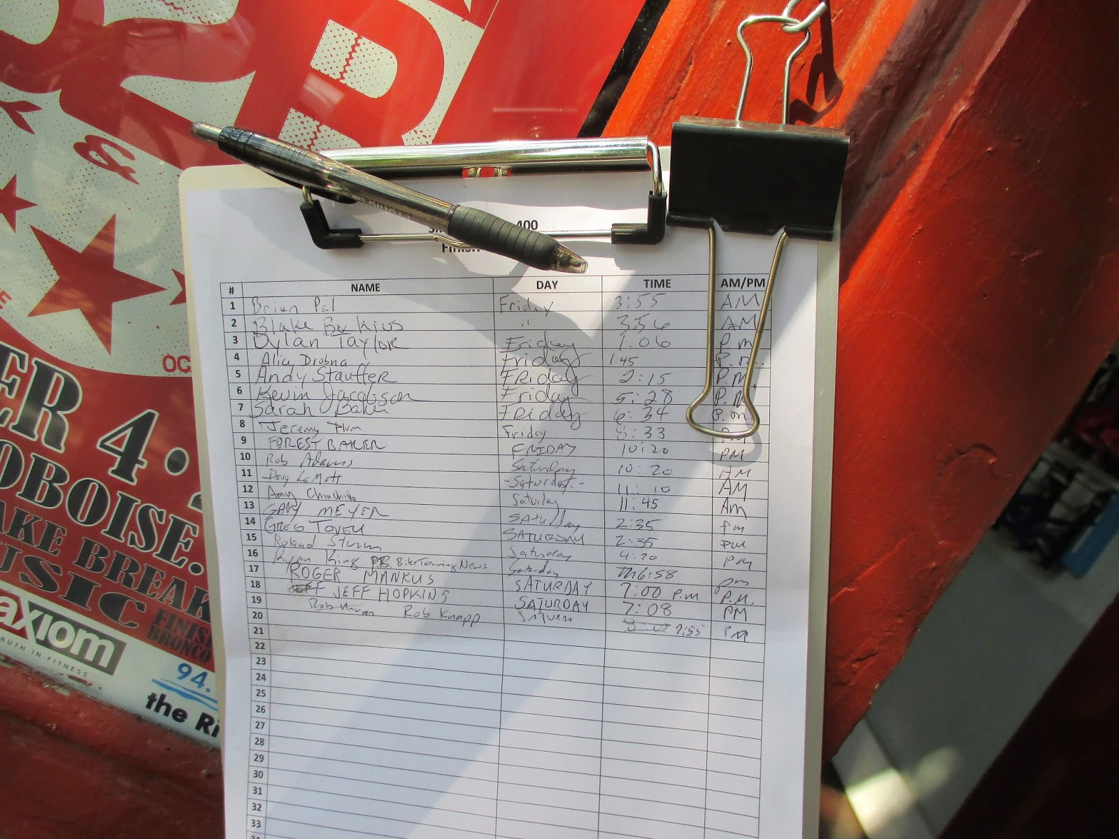
Tritown was the official end of the route and they had a sign-out sheet at their door. A few folks, including Norb, were around and some of us went across the street for food and beers and watch more riders roll in over the next several hours. The total distance was 650km and 9000 m of climbing (so just about 30 000 feet) and I was moving for about 45 hours over 3 1/2 days.

Sign-out sheet by Saturday evening:
I hung out in town the next day because my flight wasn't until Sunday evening and there was a big street fair throughout the town.

Those long rides linger in your your bones for a while as well and for the first week after coming back, I felt sluggish on the bike and just did slow road recovery rides. I didn't feel tired, but probably was. But two weeks later, I am climbing faster, by a big margin, with less perceived effort than before the trip. The first time, I thought it was a fluke ride, but now I've done my default loop (which goes from my house to the top of the Santa Monica mountains) three times in a row under 2 hours and before the trip it was always in the 2:10 range. I suspect that having been up at altitude for 5 days accounts for some of that effect, but that fun trip had about the same training effect as 2 months of determined hard training (which is too much work for me).
No comments:
Post a Comment
Note: Only a member of this blog may post a comment.